& Saint Lawrence Seaway
 The 1000 islands were formed almost 11,000 years ago at the end of the last ice age. Three previous ice ages also contributed to the formation of the islands and they actually form a connecting bridge between the Canadian Shield
to the north and the Adirondack mountains to the south in New York State.
The 1000 islands were formed almost 11,000 years ago at the end of the last ice age. Three previous ice ages also contributed to the formation of the islands and they actually form a connecting bridge between the Canadian Shield
to the north and the Adirondack mountains to the south in New York State.
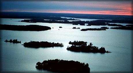
The original inhabitants of the 1000 Islands called it Manitouana, "The Garden Of The Great Spirit". The first native people came to the 1000 Islands around 7000 years ago. We know of their presence from a stone hunting point found on Gordon Island. It came from 9000 to 7000 years ago. Between 700 B.C. and 1600 A.D., the 1000 Islands were a favorite camping ground of the Iroquois, Several Iroquois tribes of Cayuga, Mohawk, Tuscarrora, Onandaga, Seneca, and Oneida formed a confederacy. They lived on the American and Canadian main shore and traveled to the islands by dug-out canoe and then birch bark canoe. There are some 40 archeological sites in the islands, that attest to the presence of the early people. The St. Lawrence was discovered by Jacques Cartier on August 10, 1535. The early explorers made use of the Great Lakes and St. Lawrence River as a highway to the interior of Canada and the United States. Many of the famous explorers passed through the area including such well known names as Champlain, de Courcelles, Comte de Frontenac, Ren�-Robert Cavalier. The first charted map of the area was made in 1687 by Jean Desbayes who named the area "Les Milles �les", or translated to English, the 1000 Islands. During the War of 1812 the region was in the midst of historic and exciting battles for the independence of both Canadians and Americans. There are 1864 natural, and one man made, islands registered in the Thousand Islands. |


The Saint Lawrence Seaway, American-Canadian navigational project that provides a waterway and lock system along the upper St. Lawrence River in order to connect the Atlantic Ocean with the Great Lakes. Construction of the seaway began in 1954, and it was opened in 1959. The St. Lawrence Seaway is considered a great engineering feat. Its construction mainly involved clearing a throughway in a 186-mile (299-kilometre) stretch of the St. Lawrence River between Montreal and Lake Ontario. This project forged the final link in a complex of lakes, rivers, deepened channels, locks, and canals stretching across 2,340 miles (3,766 km) and ultimately linking Duluth, Minn., with the head of the Gulf of St. Lawrence. Together with the Great Lakes, the St. Lawrence system provides 9,500 miles (15,285 km) of navigable waterways. Unofficially, the entire Great Lakes-St. Lawrence system has come to be known as the St. Lawrence Seaway. The seaway allows deep-draft ocean vessels access to the rich industrial and agricultural regions around the Great Lakes.